|
Digital Files (Non-image) |
GV 007621 |
Dxf file containing survey information for Whitehills Farmstead and the surrounding area |
1990 |
Item Level |
|
Digital Files (Non-image) |
DX 001421 |
RCAHMS Structures Database, Cleish |
1991 |
Item Level |
 |
On-line Digital Images |
SC 1138816 |
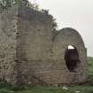
West Lethans, Pit N.1, view of mine buildings. |
1/9/1991 |
Item Level |
 |
On-line Digital Images |
SC 2196225 |
RCAHMS Survey data plotted from several sources (Cleish, map sheet NT09SW) |
1991 |
Item Level |
 |
On-line Digital Images |
SC 2196226 |
RCAHMS Survey data plotted from several sources (Cleish, map sheet NT19NE) |
1991 |
Item Level |
 |
On-line Digital Images |
SC 2196229 |
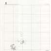
RCAHMS Survey data plotted from several sources (Cleish, map sheet NT09NE) |
1991 |
Item Level |
 |
On-line Digital Images |
SC 2196230 |
RCAHMS Survey data plotted from several sources (Cleish, map sheet NT09SE) |
1991 |
Item Level |
 |
On-line Digital Images |
SC 2196231 |
RCAHMS Survey data plotted from several sources (Cleish, map sheet NT19NW) |
1991 |
Item Level |
 |
On-line Digital Images |
SC 2196232 |
RCAHMS Survey data plotted from several sources (Cleish, map sheet NT19SE) |
1991 |
Item Level |
 |
On-line Digital Images |
SC 2196233 |
RCAHMS Survey data plotted from several sources (Cleish, map sheet NT19SW) |
1991 |
Item Level |
|
Manuscripts |
MS 731/8 |
Printout of RCAHMS Afforestable Land Survey field database (Cleish). |
1991 |
Item Level |
|
Prints and Drawings |
DC 26826 |
Transcription from vertical aerial photographs |
1992 |
Item Level |
|
Prints and Drawings |
DC 26829 |
Transcription from vertical aerial photographs |
1992 |
Item Level |
|
Prints and Drawings |
DC 26832 |
Transcription from vertical aerial photographs |
1992 |
Item Level |
|
Prints and Drawings |
DC 26833 |
Transcription from vertical aerial photographs |
1992 |
Item Level |
|
Prints and Drawings |
DC 26824 |
Transcription from vertical aerial photographs |
1992 |
Item Level |
|
Prints and Drawings |
DC 26827 |
Transcription from vertical aerial photographs |
1992 |
Item Level |
|
Prints and Drawings |
DC 26823 |
Transcription from vertical aerial photographs |
1992 |
Item Level |
|
Prints and Drawings |
DC 26825 |
Transcription from vertical aerial photographs |
1992 |
Item Level |
|
Prints and Drawings |
DC 26828 |
Transcription from vertical aerial photographs |
1992 |
Item Level |
|
Prints and Drawings |
DC 32842 PO |
Outh Hill- plan |
1992 |
Item Level |
|
Photographs and Off-line Digital Images |
D 49493 |
Coalfields of Scotland: Distribution map of Collieries in the Fifeshire and Lothians coalfields.
Map of Collieries in 1942 |
1942 |
Item Level |
|
Photographs and Off-line Digital Images |
SC 2218617 |
Coalfields of Scotland: Distribution map of Collieries in the Fifeshire and Lothians coalfields.
Map of Collieries in 1942 |
1942 |
Item Level |
|
Photographs and Off-line Digital Images |
B 94357 CS |
Knock Hill, piece of slag |
1/9/1991 |
Item Level |


